
Day Thirty
Lompoc to Ventura, 85 miles
Today would be a stretch day, mileage wise. I stuffed down lots of motel breakfast, including two bowls of Lucky Charms cereal, a guilty pleasure.

All of of the visible people in Lompoc were going somewhere in cars.
The town was otherwise deserted. Lompoc is at about 1,060 feet elevation, but it is separated from the coast by a bumpy, rugged range of hills.
Right out of town Highway 1 started up into these hills, and for the next 20 miles it was good road, light traffic and ups and downs like everywhere else I’ve ridden in California. It was a quiet, peaceful ride. No more huffing and puffing, bitching and moaning from this rider. My legs are finally up to the work.
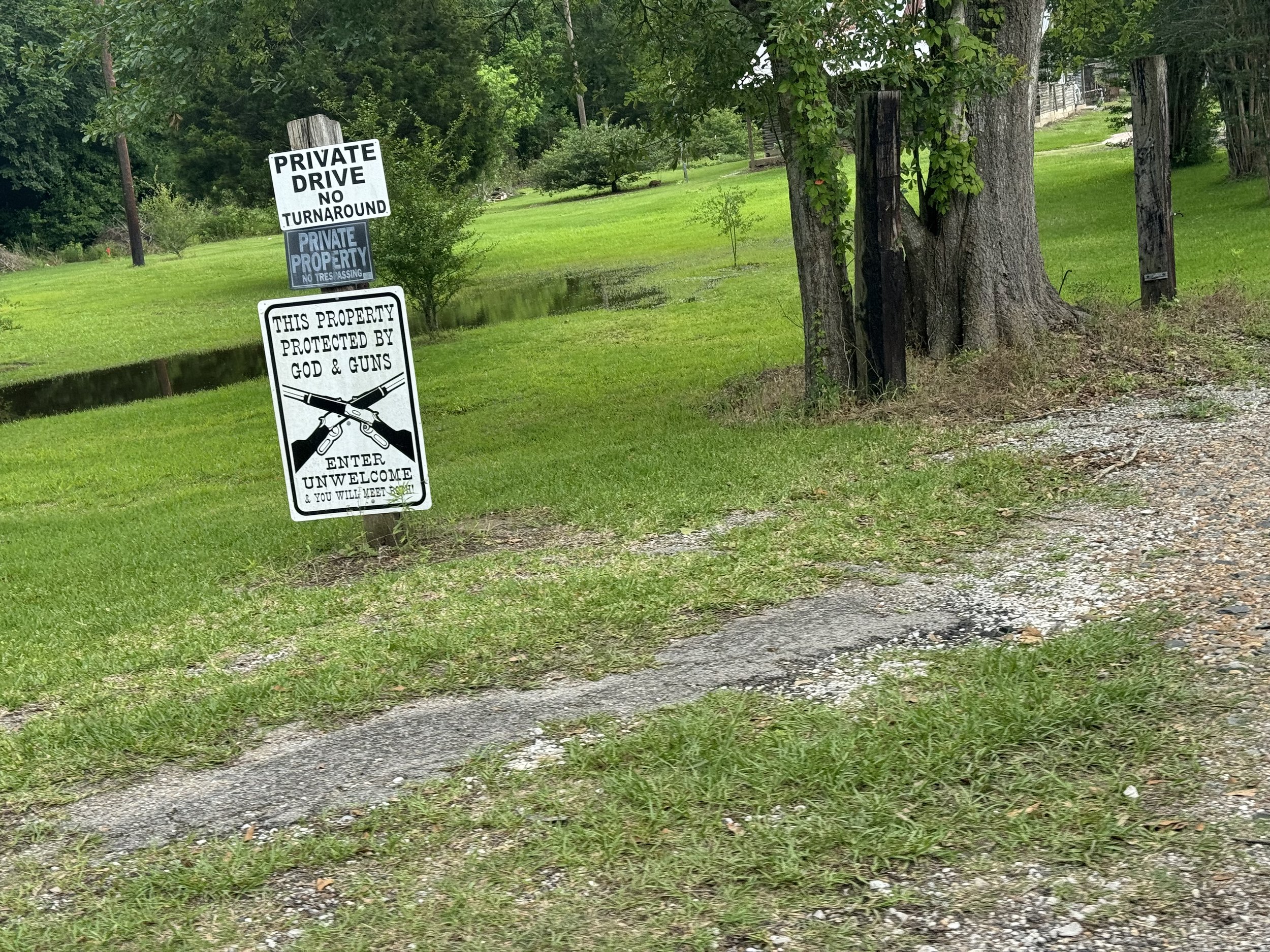
This Property Protected By God And Guns
The mountains reminded me of parts of rural Texas, except unlike Texas, not every stitch of land in California is barb-wired off at road’s edge.

As I neared the coast, it was a sudden drop in elevation into Las Cruses, and with a turn and another steep downhill, there were the beach breakers.
The coastal area between Gaviota and Ventura
The law here says that cyclist may use freeways when no other reasonable route exists. This includes about 1,000 of the gazillions miles of California freeways. But if there is a frontage road or path, they kick bikes off the freeway. It’s not that the freeway suddenly becomes dangerous, I think they are just reading the law as it is written: “reasonable alternative”. Even if the freeway is, from an engineering perspective, fine for bikes, if there is a reasonable alternative, cyclists are off the freeway. Happily, this jumping off and on US 101 is well marked and the surface streets and bike paths are in fact excellent for cycling.
There is a lot of money here and a very clear urban design aesthetic is in play. It seems a little fake, an affectation. So this evening I did some digging.
Santa Barbara’s architecture is not “fake-fake”. It’s “real-fake”, perhaps to be understood as a modern take on traditional architectural forms—an effort is to stay consistent with Spanish Colonial architectural.

Make it stand out
Afterall, the Spanish were in California early on…initially in the 16th century when Cortez’s men reached Baja, and then in 1602 when Sebastián Vizcaíno survived a huge storm on the eve of Saint Barbara’s feast day.
In the 18th century the Spanish established presidios and mission churches at San Diego, Monterey, San Francisco, and Santa Barbara.
In 1925, an 6.8 magnitude earthquake devastated downtown. The rebuild was intentionally planned and well financed. Over the years, new construction worked to compliment rather than replace or one-up the existing design feel, whether by choice or law, I don’t know. The result is that the cities and towns towns here feel cohesive, not the usual mis-mash of just-up-throw-it-up-and-get-the-doors-open we see in so many American cities.

Even the Dollar Tree has a Spanish Colonial facade.
I’m observing this as a person not completely opposed to “fake-fake”. After all, I like the Bavarian Village of Leavenworth in the Cascade Mountains. The towns along this coast, however, have deeper roots, thicker wallets and they have done a tremendous amount with both their cultural and financial resources.

I met another distance rider! Only the fourth, I think during the whole trip. Bob left Colorado for San Francisco, turned down the coast, and from LA he’ll work his way back to Colorado, without a route or end date set. He said he’s liking the road better than home, so maybe he’ll get there and just keep going?
Bob’s bike is nicely dialed in for his mission. You’ll recall my meeting Jerne at Umpqua Lighthouse State Park, the retired German policeman cycling from the Arctic to Patagonia? Jerne’s bike was set up for the long haul, but very crisply, with no frills, just what was needed. The German engineering mindset at its best.
Bob’s bike was set up like a well appointed living room, not heavy, but with lots of custom details like aerobars, several different compfie handgrips, a mirror, lights all over, a Bluetooth speaker, and probably 6 water bottles stationed here and there. He has moved into his bike and is there to stay for awhile. At 4:30 PM, Bob was calling it a day and heading for a nearby hiker/biker campsite. I still had 22 miles to lay down.
Santa Barbara: Hollywood of the North
Charlie Chaplin’s Flying A studio, and others produced over 1,000 silent films from 1912 to 1917.
Chaplin then moved to LA and established a new studio. He left it after being targeted as being a communist during the Red Scare. The Henson family bought it in 2000.
Santa Barbara: Environmental Protection Catalyst
The California oil industry pumped tremendous quantities of oil and brought in tremendous quantities of dollars. The wells started, on land, near natural seeps, then began moving off shore, but not far, because divers could only go down about 150 feet before decompression sickness became a limiting factor. In 1962, abalone diver, Dan Wilson, used oxy-helium mixed gas (Heliox) as his breathing gas and dove 400 feet.
In1969 the Union Oil Company well number 21 under Platform A, located 5.5 miles southeast of Santa Barbara, California, in the Dos Cuadras field, experienced a blowout while drill bits were being changed. The resulting oil spill of 3 million gallons—nearly the size of Chicago—shocked and dismayed people both locally and nationally.
“The company was allowed to drill without installing steel casing pipe to the depth usually required by federal regulations and as a result, unimpeded oil and gas under tremendous pressure opened five separate gashes in the soft sandstone seabed. So much gas bubbled to the surface near Platform A that the water appeared to boiling. ”
The oil spill was a catalyst for environmental ethics being written into law, including the environment protection acts to protect habitats, resources, and marine life. The first Earth Day was in April, 1970 and the Environmental Protection Agency (EPA) was establihed in December, 1970. The US president overseeing the birth of environmental protection as a federal mandate was the former US senator from California, Richard Nixon.
The book that most influenced my own life course is “Wilderness and the American Mind”, written by Roderick Nash, a professor at UC Santa Barbara, and the founder of one of the nation’s first college environmental studies programs. Nash was one of many local scholars, leaders and activists whose collective efforts brought much of the world into a much greater state of awareness of the need for environmental stewardship and the legal and governmental teeth to make it happen.
Can I finally say that my roller coaster ride through California mountains is done? I think so. The next 63 miles of today’s ride was flat—I no longer call little 200 foot rises “hills” anymore. From where I dropped out of the mountains at Gaviota this morning, to the beach park at the Mexican border, is about 275 miles of flat.
To sum up, today I cycled through one of the most interesting, and to my mind one of the most positively influential, places on the planet. And the weather was nice, as it apparently almost always is.

I rolled into the Clocktower Inn in Ventura at about 6:30 PM, having covered 85.4 miles, my greatest daily distance of this ride. My habit has become to eat big during the day and light in the evening, which tonight took the form of a spinach, avocado and chicken salad swished down with a locally brewed Mexican-style lager. There have been evenings when “light” meant three hard shell tacos from Taco Bell. This was much better.
Tomorrow it’s on through Malibu and into the LA metropolis proper. Fitness-wise, I am now fully recovering with one night’s sleep, even from even long days like today. Tomorrow, I’ll just push as far south as I can, and see where I end up. The “275 miles of flat” I mentioned above was from when I first hit the beach this morning. From Ventura I have just over 200 miles to go, depending on twists and turns through the LA basin. Three more days! It’s Monday. I should look over the border into Mexico on Thursday, Friday at the latest.
